
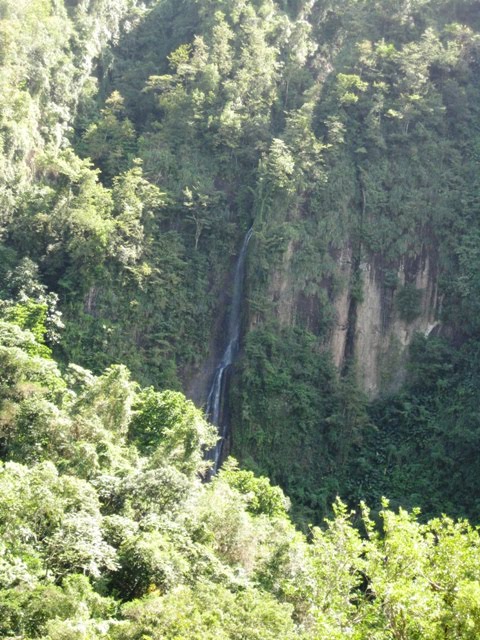
Waterfalls we saw along the way:
Dawn on the rock wall:

A view of a town, a way down there!

Jill and Tony from s/v Nychea

Dawn is installing pictures of the canal and the views, but I’ll still try to describe it. Most of the time, you are walking along an 18” bit of rough concrete, sometimes slimy and slippery, with a 2’ wide canal on your left. You can lean in at times and touch the mountain beyond, and sometimes the foliage has you leaning out. At least a third of a time, there is a deadly drop to the right. Indeed, at least a fifth of the time, you would have a 200’ free fall, then 300’ of steep foliage before finally hitting 500 more feet of barely sloping cliff. We actually couldn’t make out the rest, and would not know where to look to see the body. What fun!
However, we were deep in the mountainous rain forest and the scenery was fabulous. We looked down into beautiful valleys, across to steep mountains and cliffs, and even a very tall, but low volume waterfall. The canal walk itself took about 1.5 hours, and covered approximately 3 miles; with the canal only rising 7 metres or so over the distance. The purpose of the canal, of course built by slaves motivated likely by whips and the hope of being fed, was to bring water to a small valley that, unlike everywhere else on this end of Martinique, did not have its own source of water. Its economic value must still be proven, as it is being maintained in reasonable order.
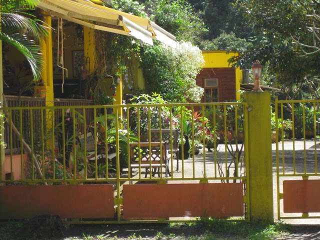
At the end of the walk, we caught a glimpse of the promised restaurant with beautiful flowered gardens, and shady, cool sitting areas. We arrived at the gate, but alas, the gate was closed and the restaurant was NOT open!!
In this photo, we finally see a hint of civilization and our mouths begin to water...

The restaurant or is it a mirage? Shame it was closed!
At the upper end of the walk, there was no town, although after 20 minutes of walking even steeper roads, we found three elderly locals in the tiniest of stores who sold us some fabulously cold Heineken and would talk slowly enough that we could make out a promise of a bus about a mile uphill. The uphill roads were so steep that we could reach out with our hands and crawl along! We found a beautiful little village, with a bus stop with even some shade, and the bus arrived right on time. However, the bus driver stopped, and yelled “Je vais a manger”, meaning; “I’m going for lunch”. When we tried to find out when or even if he was returning, he just repeated himself louder and angrier before driving away. So… we sat down and waited almost an hour. It was now approaching 3:30, we were high in the mountains, Dawn had stubbed her toe on the steep walk upwards and could not walk further, and there was no hope of a taxi. We started to walk, but had only walked 10 minutes when the bus returned and picked us up. No apologies, no communication. Well, that’s the Caribbean for ya.
Inside a little store (shed), we purchased a cool one to keep up our spirits for the walk to the bus stop.

We see goats everywhere, but this new baby, less than an hour old caught our attention! Born right along the roadside!

After rushing to get to this bus stop on extremely steep roads, this was to be our digs for the next hour and a half:

The rest of the time in St. Pierre, we did some local sightseeing with our new friends from “Jackfish” (Vancouver), and simply lounged and read.
We left yesterday for Dominica at 6:15 am, even though the forecast was for 20 knots, a bit much for us. We had the boat well reefed down, and simply hung on. We averaged almost 8 knots in the straight between the islands, and it passed quickly. The sail up the coast to the north end was very lovely; but with 9 hours under way, we were truly tired. However, Dawn cooked a great lasagne, and we had a very nice evening on the boat. The boat took a couple hours of cleaning due to the heavy amount of salt water shipped into the cockpit and over everything outside. . We’ll tell you more about Dominica soon. Dawn just purchased internet wifi, so communication for the next little while will (should) be good.
On a completely different note, while in St. Pierre, Laurie enjoyed a little shopping in this store. The lady in charge giggled when he kept sizing me up!
